
From a story over at the Globe and Mail: Researchers at the School of Conservation, part of the Royal Danish Academy of Fine Arts have studied the circa 1440 map for five years. Their conclusion? The map is almost certainly authentic, "All the tests that we have done over the past five years – on the materials and other aspects – do not show any signs of forgery" (Rene Larsen, Rector of the School of Conservation). The map shows Vinlanda Insula (way to the left, in the upper corner), the Vinland of Icelandic scholars (click here for a larger version). This area is now linked to Newfoundland and Labrador, where there is extensive archaeological evidence of Norse settlement dating to AD 1000 at L'Anse aux Meadows. The L'Anse aux Meadows site is a National Historic Site in Canada, as well as a UNESCO World Heritage Site (sorry for the link to Wikipedia; the Parks Canada website for L'Anse aux Meadows is being fussy).
I enjoy working with historic maps, tracing the history of an area back through time. Actually, I usually trace the history forward through time. I should try writing it the other way sometime; see what that does. Anyway... the maps. More recent maps are great for me as an archaeologist, because they tend to be more accurate (not completely accurate, mind you). Using these maps, I can address very specific locations of archaeological sensitivity or areas that have been disturbed to the point that no archaeological resources are likely to remain intact. Very practical!
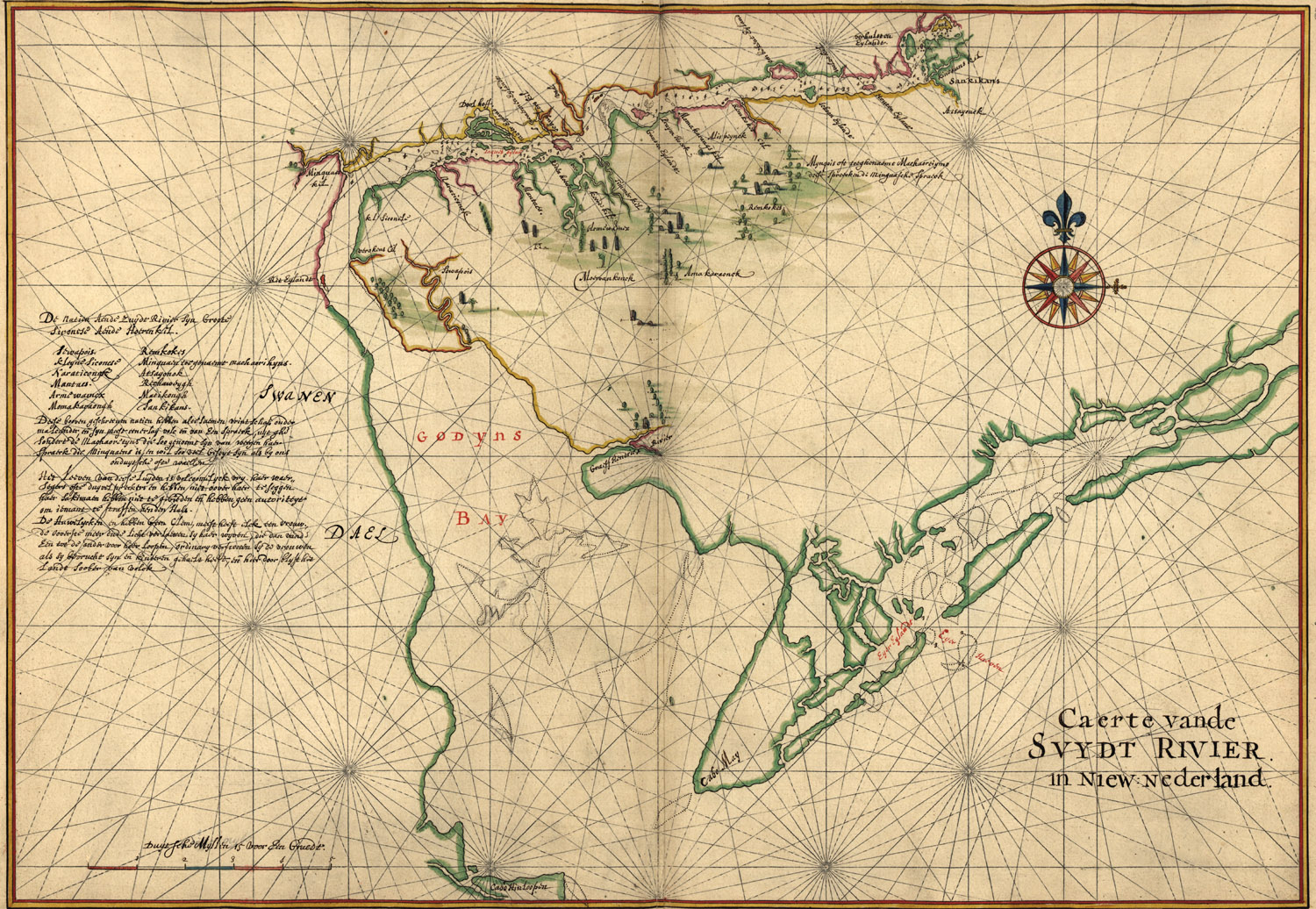
But I really love working with the earlier maps. The ones with pictures of whales in the water; the ones that look more like landscape paintings than maps; the ones with coastlines that make sense if you're drawing them from a boat as you pass and are helpful for other mariners, but don't seem to make a lick of sense in any other context. Despite my "Here be Dragons" romanticism, these maps also often contain good information about the relationships of things and people. To interpret these, I have to look at landmarks, and think about things that were important enough to record. Here's one of my favorites of the Delaware River, "Caert vande Svydt Rivier in Niew Nederland" by Joan Vinkeboons c. 1639 (you can see it larger here):

4 comments:
I adore old maps, especially all the artistic flourishes like whales and other sea creatures. I also like the way they challenge our 'received' view of the world - the one that puts North America and Europe at the centre of everything. I really like the medieval maps that put Jerusalem at the centre of the world.
Or south at the top of the page; it's amazing how used to North being Up we are.
If this opinion about the "Vinland Map" holds, I think it will be a real reversal. I remember reading that up until recently, the general consensus was that the "Vinland" portion of the map was a forgery.
I like the older maps partly because they are a mixture of precise empirical information with imagination which often reflected the hopes and fears of the people who drew and commissioned them.
RPS77, thanks for stopping by! I agree, the authentication, if it holds, will be a big change. I find it entirely possible that knowledge of some sort of land in that general vicinity was passed along; we often forget about or slight oral history, probably because it's so elusive. Sure, the specifics may change (i.e., specific coastline landmarks, etc.), but the gist could well have survived.
Post a Comment